Sixth Settlement & Fifth Settlement Detailed Map (PDF): Complete Guide to New Cairo Districts, Roads & Locations
Introduction
New Cairo has become one of Egypt's most important urban destinations, attracting homebuyers, investors, and businesses looking for modern residential communities and promising real estate opportunities. As the city continues to expand, understanding its geographical layout has become increasingly important, particularly when exploring the Fifth Settlement and the newly developing Sixth Settlement.
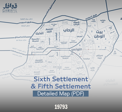
A detailed Sixth Settlement and Fifth Settlement map PDF provides a practical way to understand the layout of both areas, identify their main districts, explore surrounding roads, and locate important residential and commercial destinations. Whether you are planning to purchase an apartment, invest in a property, or simply explore New Cairo, having access to an accurate map can make the decision-making process much easier.
Both settlements offer different advantages. The Fifth Settlement is an established urban destination with residential neighborhoods, commercial centers, educational institutions, and healthcare facilities. Meanwhile, the Sixth Settlement represents a newer urban extension that is attracting attention because of its location, development plans, and connectivity to major roads in East Cairo.
In this guide, we will explore the detailed maps of the Fifth and Sixth Settlements, highlight their main districts, explain the importance of their road networks, and discuss how to use these maps when choosing a suitable residential or investment property.
1. Why Do You Need a Detailed Fifth and Sixth Settlement Map PDF?
A detailed city map is more than a navigation tool. It provides valuable information about the geographical organization of an area and helps users understand how different neighborhoods, roads, and facilities are connected.
Searching for a Fifth Settlement and Sixth Settlement detailed map PDF can be particularly useful for people who want to explore New Cairo before visiting or purchasing a property.
Here are some of the main benefits of using a detailed map.
Understanding the Different Districts
A detailed map helps users identify residential neighborhoods, commercial zones, and surrounding developments. It also makes it easier to understand the geographical relationship between different districts.
Identifying Main Roads and Highways
Road connectivity is one of the most important factors when evaluating a real estate location. Maps help identify major roads and transportation routes connecting the Fifth Settlement and Sixth Settlement to other parts of Cairo.
Locating Essential Services
Maps can help users understand the location of important facilities, including schools, universities, hospitals, shopping malls, and recreational destinations.
Comparing Real Estate Locations
For property buyers and investors, comparing different locations is essential. A detailed map makes it easier to evaluate accessibility, surrounding developments, and proximity to essential services.
Planning Property Visits
If you are visiting several residential projects, a map can help you organize your journey, identify nearby roads, and locate the exact project address.
2. Fifth Settlement Detailed Map: An Overview
The Fifth Settlement is one of the most established districts within New Cairo. It has developed into a major residential and commercial destination, offering a variety of housing options, business facilities, shopping destinations, and educational institutions.
The Fifth Settlement map provides an overview of its neighborhoods, main roads, and surrounding developments. It is particularly useful for identifying the relationship between residential districts and important commercial areas.
Main Districts in the Fifth Settlement
The Fifth Settlement includes several residential neighborhoods, each offering different characteristics and property opportunities.
1. Narges District
Narges is one of the recognized residential areas in the Fifth Settlement. It includes different residential buildings and housing options that appeal to families and individuals searching for properties in New Cairo.
The district offers a range of residential opportunities, making it worth considering when comparing different neighborhoods.
Understanding its location through a detailed map helps buyers identify nearby roads, surrounding districts, and access to essential services.
2. Lotus District
Lotus is another important residential area in New Cairo. It is commonly divided into Northern Lotus and Southern Lotus.
The area has attracted interest from property buyers because of its location and residential developments.
A detailed map helps identify the district's position in relation to major roads and nearby neighborhoods, allowing buyers to evaluate its accessibility.
3. Andalus District
Andalus is a residential area within New Cairo that includes different housing developments and residential projects.
When exploring this district, buyers should pay attention to the exact location of each project, nearby streets, available services, and accessibility to major roads.
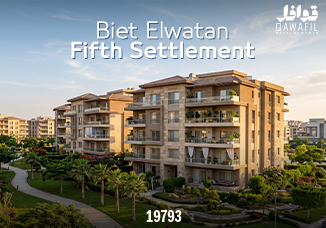
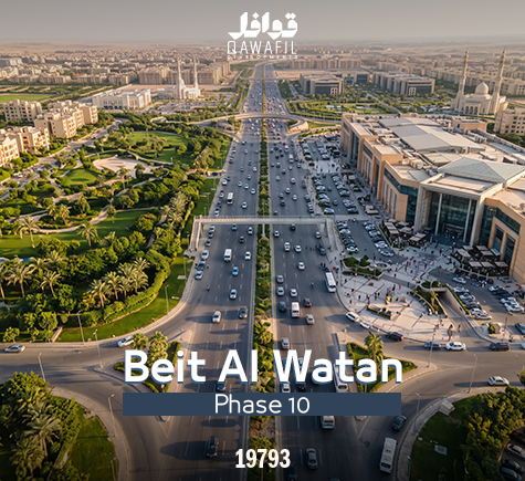
4. Beit Al Watan
Beit Al Watan is one of the important real estate destinations in New Cairo. It has attracted considerable interest from buyers and investors because of its location and the variety of residential developments taking place throughout its districts.
The area is divided into several neighborhoods, and a detailed map can help users understand their locations and connections to surrounding districts.
It is particularly important to identify the exact neighborhood and plot location before purchasing a property.
5. Investors Districts
The Northern and Southern Investors Districts are among the residential areas associated with the Fifth Settlement.
They include different residential developments and apartment buildings. Their locations should be evaluated according to accessibility, surrounding services, and proximity to major roads.
6. Karnak District
Karnak is another residential destination that attracts buyers exploring New Cairo.
Understanding its position in relation to nearby neighborhoods and main roads can help potential buyers evaluate the location and compare available residential opportunities.
The Importance of North and South 90th Street
When studying the Fifth Settlement map, North and South 90th Street are among the most important roads to identify.
They play a major role in connecting residential neighborhoods with commercial, administrative, educational, and recreational destinations.
North 90th Street
North 90th Street is an important commercial and business corridor. It provides access to several commercial developments, offices, and other facilities.
South 90th Street
South 90th Street serves several residential and commercial destinations and is one of the major roads supporting movement throughout the Fifth Settlement.
Connecting Roads
Several internal roads connect the surrounding neighborhoods to the main 90th Street corridors, making it important to understand the exact entrance and access route of each project.
3. Sixth Settlement Detailed Map: Location and Main Features
The Sixth Settlement is one of the newer urban extensions in the New Cairo area. It has gained attention because of its strategic position in East Cairo, its developing infrastructure, and its connection to important highways.
The Sixth Settlement detailed map PDF helps users understand the general location of the area, its surrounding developments, and the major roads connecting it to other destinations.
As the area continues to develop, some road layouts, project boundaries, and infrastructure details may change. Therefore, users should always consult updated official planning documents before relying on specific plot boundaries or land-use information.
Where Is the Sixth Settlement Located?
The Sixth Settlement is part of the wider urban expansion of East Cairo and New Cairo.
Its location provides connections to several major transportation routes, making it relevant to people looking for residential and investment opportunities in emerging urban destinations.
Some of the important roads and routes associated with the area's wider connectivity include:
Ain Sokhna Road.
Middle Ring Road.
Regional Ring Road connections.
South 90th Street and connecting roads.
Roads leading toward the New Administrative Capital.
These connections contribute to the area's importance within the expanding urban landscape of East Cairo.
What Does the Sixth Settlement Map Show?
A detailed map can help users understand several important aspects of the district.
1. Geographical Boundaries
A map provides an overview of the Sixth Settlement's geographical location and its relationship with the Fifth Settlement, New Cairo, and nearby urban developments.
2. Main Access Roads
Identifying major highways and connecting roads helps residents and investors understand how to reach the area from different parts of Cairo.
3. Residential Developments
As real estate activity increases, identifying the location of residential projects becomes increasingly important.
A map allows potential buyers to compare projects based on their proximity to major roads and surrounding facilities.
4. Commercial and Service Areas
Maps can also help users understand the distribution of different land uses, including residential, commercial, and administrative activities.
However, the approved planning documents should always be consulted when verifying the permitted use of a specific plot.
4. Fifth Settlement vs. Sixth Settlement: What Is the Difference?
Although both areas are part of the wider New Cairo development, they have different characteristics and development stages.
Understanding these differences can help buyers and investors identify which location is more suitable for their objectives.
Comparison | Fifth Settlement | Sixth Settlement |
|---|---|---|
Development stage | Established urban destination | Newer urban extension |
Property market | Diverse residential and commercial options | Emerging residential and investment developments |
Services | Established network of services | Services developing alongside expansion |
Urban planning | Established neighborhoods and districts | Newer planning and expansion areas |
Accessibility | Connected to major New Cairo roads | Connected to major East Cairo highways |
Real estate opportunities | Existing residential and commercial market | Opportunities linked to future urban growth |
Which Settlement Is Better for Living?
The answer depends on individual preferences and lifestyle requirements.
The Fifth Settlement may be more suitable for people who prefer established neighborhoods with existing schools, shopping destinations, healthcare facilities, and other everyday services.
The Sixth Settlement may appeal to buyers interested in newer residential developments and areas undergoing urban expansion.
However, choosing the right property requires evaluating the exact project location rather than relying only on the settlement's name.
Which Settlement Is Better for Real Estate Investment?
Both locations offer opportunities that deserve consideration, but their investment characteristics are different.
The Fifth Settlement has an established real estate market, allowing investors to study existing demand across different neighborhoods and property categories.
The Sixth Settlement is an emerging development area, where investment decisions should consider infrastructure progress, project delivery schedules, accessibility, developer reputation, and future demand.
There is no guaranteed investment return, so buyers should conduct proper research before committing to a purchase.
5. Main Roads Connecting the Fifth and Sixth Settlements
Transportation infrastructure plays an important role in determining the accessibility and attractiveness of any real estate location.
When examining the Fifth and Sixth Settlement maps, it is important to understand the major roads connecting New Cairo to other parts of Greater Cairo.
1. The Ring Road
The Ring Road connects New Cairo to several destinations across Greater Cairo and provides alternative routes for people traveling between different districts.
2. Cairo–Suez Road
Cairo–Suez Road is one of the major highways serving East Cairo. It connects New Cairo with several surrounding areas and supports access to important destinations.
3. Ain Sokhna Road
Ain Sokhna Road is an important transportation corridor serving the eastern expansion of Cairo. It also provides connections toward the Ain Sokhna coastal area.
4. Middle Ring Road
The Middle Ring Road supports connectivity between several developing urban communities and is an important route when evaluating property locations in East Cairo.
5. 90th Street
North and South 90th Street are among the main transportation and commercial corridors within the Fifth Settlement.
They connect numerous residential neighborhoods with shopping destinations, business centers, and essential facilities.
6. How to Use the Fifth and Sixth Settlement Map PDF
Downloading a map is only the first step. To make the most of it, buyers and investors should understand how to use it when researching a property.
Step 1: Download a Clear PDF Map
Look for a high-resolution PDF that clearly displays district names, roads, and geographical information.
Make sure the map has a publication date and identifiable source.
Step 2: Identify Your Target District
Start by identifying the neighborhood or area you want to explore.
Then examine its location in relation to major roads and surrounding residential developments.
Step 3: Locate the Exact Real Estate Project
Do not rely solely on the name of the district.
Request the exact project address or location coordinates and verify that they correspond to the information provided by the developer.
Step 4: Examine Nearby Services
Check the distance between the property and important facilities such as schools, hospitals, shopping centers, and daily services.
Step 5: Evaluate Infrastructure
Identify which roads and facilities are already operational and which are still planned or under development.
This distinction is particularly important when evaluating newer urban extensions.
Step 6: Verify the Map's Source
Not all online maps are official or updated.
Before making a real estate decision, check the publication date and verify important details through the relevant government authorities.
7. Download the Fifth Settlement and Sixth Settlement Detailed Map PDF
If you are searching for a detailed Fifth Settlement and Sixth Settlement map PDF, it is important to distinguish between general location maps and officially approved planning documents.
Different maps serve different purposes.
For the Fifth Settlement:
Look for official New Cairo planning maps and district layouts through the relevant authorities, particularly the New Urban Communities Authority and the New Cairo City Authority.
For the Sixth Settlement:
Consult updated planning documents relating to the newer urban expansion areas. Make sure that the map reflects the latest available planning information.
For Navigation:
Google Maps can help identify actual roads, directions, and existing locations. However, it should not replace official documents when checking land boundaries or approved land uses.
For an additional geographical reference, you can consult the Aqarmap Trends 2025 Report PDF, which includes a visual map of the Sixth Settlement as part of its real estate market analysis.
Important: A general map is not necessarily an official cadastral or planning map. Always verify plot boundaries, district divisions, and permitted land uses through the relevant authorities before making a purchase.
8. How Can a New Cairo Map Help You Choose the Right Property?
A detailed map can make property research more organized and help buyers compare different locations.
However, geographical information should be combined with other important real estate considerations.
1. Accessibility and Road Connectivity
A property's distance from major roads can influence how convenient it is for daily travel.
Consider the actual route to the property, available entrances, and connections to the main road network.
2. Proximity to Essential Services
Schools, hospitals, pharmacies, supermarkets, and shopping centers can significantly influence residential convenience.
Properties located near important services may also attract greater interest from potential tenants and buyers.
3. Surrounding Development
Study the developments surrounding the property.
Determine whether the area is primarily residential, commercial, administrative, or mixed-use.
4. Infrastructure Progress
Check the actual status of roads, utilities, and public facilities.
A planned facility should not automatically be treated as an operational service.
5. Developer Reputation and Construction Quality
The location is important, but the developer is equally important.
Review the developer's experience, previous projects, construction quality, contractual commitments, and delivery history before making a decision.
9. Qawafil Developments and Its Presence in New Cairo
When exploring the Fifth Settlement and Sixth Settlement maps, it is also useful to understand the real estate developers operating throughout New Cairo.
Knowing where a developer's projects are located can help buyers connect geographical information with actual residential and investment opportunities.
Qawafil Developments is an Egyptian real estate development company established in 2008. The company expanded its activities into New Cairo in 2016, focusing on strategic location selection, engineering expertise, and the development of residential and commercial properties.
Its developments include locations such as Beit Al Watan, Narges, Lotus, and Andalus, giving buyers different opportunities to explore residential projects throughout New Cairo.
For anyone researching the Fifth Settlement and its surrounding neighborhoods, Qawafil's project portfolio provides an additional reference for understanding real estate opportunities in these areas.
You can explore the company's background through its official Qawafil Developments website, learn more about its current real estate projects, and discover its company profile and development vision.
By examining the location of each project alongside the surrounding roads and facilities, potential buyers can make more informed comparisons and identify properties that match their residential or investment objectives.
10. Important Tips Before Buying Property in the Fifth or Sixth Settlement
Purchasing a property requires more than identifying an attractive location on a map.
Before making a final decision, consider the following recommendations:
Request the exact location of the project on a map.
Verify the project's legal documentation, land status, and relevant permits.
Visit the property location to evaluate its surroundings.
Check the actual distance to essential facilities.
Ask about the current status of roads and infrastructure.
Review the construction specifications and available unit layouts.
Examine the sales contract, payment schedule, and delivery conditions.
Compare several developments before selecting a property.
Research the developer's previous projects and delivery record.
Distinguish between existing facilities and services that are only planned for the future.
These steps can help reduce uncertainty and make the purchasing process more transparent.
Frequently Asked Questions About the Fifth and Sixth Settlement Map PDF
1. Where Can I Download the Fifth Settlement Map PDF?
You can search for New Cairo maps and planning documents through the relevant official authorities, including the New Urban Communities Authority and the New Cairo City Authority.
Always verify the map's publication date and whether it is an approved document.
2. Is There a Detailed Sixth Settlement Map PDF?
There are illustrative maps and real estate reports showing the Sixth Settlement's geographical location. For precise district divisions, plot boundaries, and approved land uses, consult the relevant official planning documents.
3. What Is the Difference Between the Fifth and Sixth Settlements?
The Fifth Settlement is an established urban area with residential neighborhoods and a developed service network. The Sixth Settlement is a newer urban extension experiencing continued development and expansion.
4. What Are the Main Roads Leading to the Fifth Settlement?
Important roads include Cairo–Suez Road, the Ring Road, North 90th Street, South 90th Street, and several internal connecting roads.
5. What Are the Main Roads Connecting the Sixth Settlement?
The Sixth Settlement is connected to the wider East Cairo road network, including Ain Sokhna Road, Middle Ring Road, and connecting routes serving the surrounding developments.
6. Can a Detailed Map Help Me Choose an Apartment?
Yes. A map can help you compare different locations, identify nearby facilities, and understand road accessibility. However, you should also visit the property and verify its documentation and construction quality.
7. Is the Sixth Settlement a Good Real Estate Investment Opportunity?
The Sixth Settlement may offer opportunities associated with New Cairo's urban expansion. However, investment suitability depends on the exact location, developer, infrastructure, property price, expected demand, and delivery timeline.
8. Can I Use Google Maps Instead of an Official Planning Map?
Google Maps is useful for navigation and identifying existing roads and destinations. However, it should not be used as a substitute for official planning documents when verifying plot boundaries, land divisions, or permitted land uses.
Conclusion
The Fifth Settlement and Sixth Settlement detailed map PDF is a valuable resource for anyone exploring New Cairo's residential and investment opportunities.
Understanding the geographical layout of both areas, identifying their neighborhoods, and examining the main roads and surrounding facilities can make property research easier and more effective.
While the Fifth Settlement offers established residential and commercial destinations, the Sixth Settlement represents a newer phase of urban expansion in East Cairo.
Regardless of which area you choose, a successful real estate decision should be based on accurate geographical information, careful evaluation of the developer, construction quality, infrastructure progress, and the property's suitability for your needs.
With New Cairo continuing to develop, staying informed about updated maps and approved planning documents is essential for anyone planning to live or invest in this growing urban destination.
Article summary
A detailed Sixth Settlement and Fifth Settlement map PDF provides a practical way to understand the layout of both areas, identify their main districts, explore surrounding roads, and locate important residential and commercial destinations. Whether you are planning to purchase an apartment, invest in a property, or simply explore New Cairo, having access to an accurate map can make the decision-making process much easier. Both settlements offer different advantages. The Fifth Settlement is an established urban destination with residential neighborhoods, commercial centers, educational institutions, and healthcare facilities. Meanwhile, the Sixth Settlement represents a newer urban extension that is attracting attention because of its location, development plans, and connectivity to major roads in East Cairo.
- This article focuses on Commercial in 5th Settlement for buyers and investors.
- A strong property decision compares options and looks at total cost of ownership.
- Book a consultation with Qawafil to apply these insights to your situation.
FAQ
Frequently asked questions
Short answers to the questions readers ask most after this article.
This article offers general guidance. For a recommendation tailored to your budget and goals, book a consultation with a Qawafil advisor.
We review content regularly against the latest market data. The publish date at the top of the article is your reference.
Use the consultation form in the sidebar, or contact us via the contact page — we typically reply within 24 hours.
Yes. Related posts appear below, and you can browse the full blog archive anytime.